

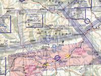
Refer to figure.
A Pilot is planning a direct flight from aerodrome Zeltweg (LOXZ) to aerodrome Trieben (GOGI), where variation is 002°E. What is the highest point within 5 NM either side of the direct track?
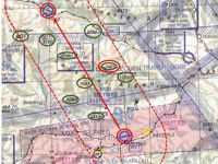
Refer to figure.
When planning a VFR route, among other considerations, you should also take into account the height of the obstacles within a band of 5 NM on each side of your planned route, so as to establish the highest terrain.
1. First of all, find the position of the Zeltweg (LOXZ) and Trieben (GOGI) aerodromes, and connect them by drawing a line with your pencil.
2. Draw a band of 5 NM on each side off the route line and mark all the natural or man-made obstacles within the band (The chart scale is not known. So, applying the rule: 1' = 1 NM along a meridian, measure 5 NM along a meridian).
3. Also, overhead each aerodrome, mark obstacles within a 5 NM radius.
4. The highest obstacle within the 5 NM band off the course line, is a spot elevation with an elevation 7926 ft AMSL.
Your Notes (not visible to others)
This question has appeared on the real examination, you can find the related countries below.
-
Austro Control1


 Use Keyboard Shortcuts
