

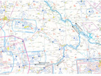
Refer to figure.
A pilot is preparing a flight from Vilshofen (EDMV, N48°38.1′ E13°11.7′) to Regensburg (EDNR, N49°08.5' E012°04.9'), with no access to radio navigation aids. Weather conditions are suboptimal, hazy visibility is reported along the planned path, and the sun is positioned low, potentially impairing forward vision. Given these limitations, what would be the most appropriate routing choice?
-
A
Straight from EDMV to Roding VOR, then to EDNR.
-
B
Following the A3 highway past Straubing to Regensburg city, just clipping the edge of the class F airspace, turning right up the A93 to EDNR.
-
C
Straight to EDNB and the straight to EDNR.
-
D
A straight line from EDMV to the lighted tower (height 1848 ft) just east of Pfaffenberg, then straight to EDNR.
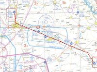
Refer to figure.
The A3 motorway runs near the departure aerodrome and leads toward Regensburg, passing through Straubing. From Regensburg, you can follow the A93 motorway, which goes straight to the destination aerodrome. This route provides continuous visual cues and is suitable for navigation without the use of radio aids.
The alternative options are less suitable because they either lack sufficient visual references or depend on radio navigation equipment, which is not operational in this scenario.
Your Notes (not visible to others)
This question has appeared on the real examination, you can find the related countries below.
-
Romania2
-
France1
-
Germany1
-
Hungary1


 Use Keyboard Shortcuts
