

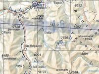
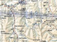
Refer to figure.
South of Zell am See (LOWZ), the maximum elevation figure (MEF) is...
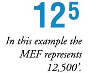
Refer to figures.
The Maximum Elevation Figure is a number shown on VFR charts which represents the highest elevation in a grid square (usually 30 minutes of latitude high and 30 minutes of longitude wide) plus a safety margin, and is rounded up to the nearest 100 ft. As such, this number shows the lowest possible altitude you could fly at in that grid square, without hitting any obstacles. The MEF is sometimes incorrectly called the "minimum safe(ty) altitude". This term has no official meaning.
The MEF is shown for every grid square, and is presented differently by different aviation authorities in different countries. However, the numbers are usually presented in hundreds of feet, in large writing - often slightly see-through.
As such, the chart section in this question shows three MEFs for three different grid squares, but south of LOWZ, the MEF is 13 000 ft.
Your Notes (not visible to others)
This question has appeared on the real examination, you can find the related countries below.
-
Austro Control1


