

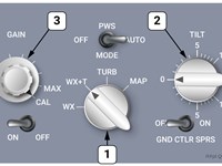
Refer to figure.
Selection of WX+T mode on rotary switch 1 will help to detect and display areas of…
-
A
Turbulence within precipitation by detecting the Doppler shift of the falling droplets.
-
B
CAT within precipitation by detecting the Doppler shift of the falling droplets.
-
C
Turbulence within precipitation by detecting the Doppler shift of the reflected radar signal.
-
D
CAT within precipitation by detecting the Doppler shift of the reflected radar signal.
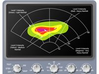
Refer to figure.
Airborne Weather Radar is a type of radar used to provide an indication to pilots of the intensity of convective weather.
Modern weather radars are mostly doppler radars, capable of detecting the motion of rain droplets in addition to intensity of the precipitation.
Doppler radars work by measuring the frequency shift in the radar returns. If an object is not moving, the return (reflected signal) will be the same frequency as the transmitted signal. If there has been a frequency shift, that will indicate that the reflecting object is moving. When water droplets are moving rapidly (due to turbulence) there will be a large frequency shift and that can be calculated as a level of intensity of turbulence. The movement of the droplets themselves cannot be measured, but it can be calculated through measuring the frequency shift of the returning radar frequencies. The only thing a radar receiver can detect is radar frequency returns. From those, other information can be calculated, but only the frequencies are detected.
Typically, the radar antenna is located in the nose of the aircraft.
Signals from the antenna are processed by a computer and presented on a screen which may be viewed by the pilots.
Droplet size is a good indicator of strong updrafts within cumulonimbus clouds, and associated turbulence, and is indicated on the screen by patterns, colour coded for intensity.
It needs to be noted that the frequency band of the radio waves (X band) is selected not to detect any cloud, small precipitation such as drizzle, fog or wind, as the droplets are too little or don’t exist.
Some airborne weather radar systems may also be able to predict the presence of wind shear.
Green: light precipitation
Yellow (or amber): medium precipitation
Red: heavy precipitation
Magenta: Extremely high precipitation
Radar Mode:
Weather only Mode (WX)
Weather + Turbulent Mode( WX+T): The areas which have strong turbulence will be showing in magenta on the display.
This area is formerly showed in green on WX only Mode.
Your Notes (not visible to others)
This question has appeared on the real examination, you can find the related countries below.
-
United Kingdom20
-
Hong Kong7
-
Austro Control6
-
Pakistan6
-
Poland6
-
Italy2
-
Lithuania2
-
Czech Republic1
-
Greece1
-
Ireland1
-
Malaysia1
-
Portugal1


