

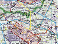
Refer to figure.
What is the highest Minimum Grid Area Altitude between BERTA (point 1) and LJLJ (Ljubljana) along route A (yellow)?
Refer to figure.
Minimum Grid Area Altitude is shown within grids defined by each one or half degree of latitude and longitude. This value is abbreviated in hundreds of feet and provides clearance of all terrain and obstacles by a safety margin (depending on the publisher).
Along route A (yellow), two grid areas are met between BERTA (point 1) and LJLJ (Ljubljana) airport:
- The first grid area has Minimum Grid Area Altitude 10 700 ft (107), between Point 1 and Point 3.
- The second one has Minimum Grid Area Altitude 9700 ft (97), between Point 3 and LJLJ airport.
Therefore, the highest Minimum Grid Area Altitude between BERTA (point 1) and LJLJ (Ljubljana) along route A (yellow) is 10 700 ft.
Your Notes (not visible to others)
This question has appeared on the real examination, you can find the related countries below.


