

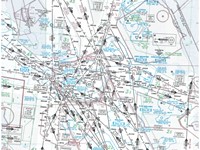
Refer to Jeppesen GSPRM Training Route Manual - Chart "E LO 2".
The following bearing and range information obtained from HONILEY (HON) VOR/DME (52°21´N, 001°40´W) is given:
Radial: 034°
Range: 44 NM
Find the current position of the aircraft (note: slant range corrections should be ignored)..
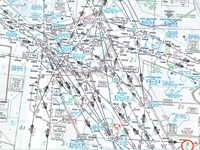
Refer to figure.
1- Locate HONILEY VOR.
2- As radials are measured in magnetic and the variation is 1˚W,
Variation West, Magnetic Best.
so 34˚(M) - 1˚ = 33˚(T)
Make a line going 033˚(T) outbound from HON VOR
3- measure the distance between any two consecutive latitudes on the chart and refer it to the fact that distance between two consecutive latitudes is (60 NM), referring to this distance make a mark on the line drawn before to represent the distance of (44 NM).
Current aircraft position: 52˚59’N, 000˚59’W
Your Notes (not visible to others)
This question has appeared on the real examination, you can find the related countries below.
-
Greece4
-
Poland3
-
United Kingdom2
-
Czech Republic1
-
Hungary1
-
Lithuania1
-
Pakistan1
-
Sweden1


 Use Keyboard Shortcuts
