

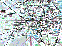
Refer to figure.
For Alghero VOR with coordinates 40°038'N, 008°015'E the correct identification, frequency, and Morse code are...
VOR identification. Unique three-letter alphanumeric code.
VOR frequency. A VHF frequency between 108.0 to 119.75MHz, tuned by the pilot to navigate using the VOR.
VOR Morse code identifier. A series of three letters that are transmitted in Morse code (a system of transmitting text using a series of dots and dashes). The three letters are unique to each VOR station and are used by pilots to verify that they are receiving the signal from the correct station, and that the VOR station is working properly.
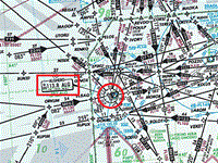
Refer to figure.
The Alghero VOR is marked on the annex, has an information box on the left hand side, giving the frequency 113.8, the three-letter identifier ALG and the corresponding morse code for those letters (._ ._.. __.).
Your Notes (not visible to others)
This question has appeared on the real examination, you can find the related countries below.
-
Austro Control59
-
Spain28
-
France21
-
Greece19
-
Poland9
-
Germany7
-
Italy6
-
Sweden6
-
Portugal5
-
Hungary4
-
Romania4
-
Switzerland4
-
Finland3
-
Lithuania3
-
Czech Republic2
-
Iceland2
-
Ireland2
-
Malta2
-
Norway2
-
Serbia2
-
Belgium1
-
Latvia1
-
Netherlands1
-
Slovakia1


