

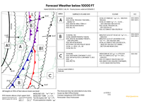
Refer to figure.
Consider a flight operating from Brussels to Paris, planned for the afternoon 2nd of July 2018, flying at 6000 ft AMSL. What type of turbulence and icing can you expect?
Refer to figure.
The forecasted weather chart is for BELOW 10000 FT - "Forecast Weather below 10 000 ft".
Valid from July the 2nd 2018 0200 UTC until July the 2nd 2018 1100UTC - "Valid 020200 to 021100 Z July 18”.
This question is quite clearly flawed, as Brussels and Paris are not even present on it, so no pilot should use this chart for flight planning, but with that being said, it does mention that the outlook until 1800z is similar, so we can assume that the regions continue to move at the same rate, and the weather within those regions remains roughly the same.
The first thing to do it to fast forward the location of the regions to the time of flight. The fronts and zones on the chart are valid at 0600z, but the flight is in the afternoon, meaning anytime from 1000z onwards (Brussels and Paris are 2 hours ahead during Summer, though we don't accept this to be part of general knowledge or the LOs for meteorology), so we have to move the zones at least 4 hours into the future. For the most important boundary, that is the boundary of region C and region B1, this means 4 hours x 15 kt = 60 NM, but this could also mean up to approximately 10 hours in our opinion (1800 local, 1600z), given no specific time of departure, which would be approximately 120 NM.
60 NM into the future, Brussels and Paris are within area C still, however 120 NM further than the chart, the border with B1 region starts to reach with the expected route. It is therefore difficult to say whether the flight would be primarily within B1 or within C. We have evaluated both regions at the end of the explanation, but here is the main point.
- Region C at 6 000 ft has clouds (ISOL SCT/BKN CU SC) with moderate icing and turbulence expected.
- Region B at 6 000 ft has clouds (BKN/OVC … CU SC) with moderate icing and turbulence expected.
- Region B1 has occasional moderate turbulence expected, with isolated severe turbulence.
Importantly, the feedback indicates that “Moderate icing and turbulence within clouds.” is CORRECT, so it is most likely that region C is being evaluated, however, it is subject to interpretation due to the poor nature of the question.
Zone C clouds forecast:
"AREAS BKN AC AS MOD ICE MOD TURB 070/XXX"
- Areas of broken altocumulus and altostratus clouds with bases of 7000 ft and tops above 10 000 ft. Moderate icing and moderate turbulence expected in these clouds.
"ISOL SCT/BKN CU SC MOD ICE MOD TURB 025-050/070"
- Isolated areas of scattered or broken cumulus and stratocumulus clouds with bases of 2500/5000 ft and tops of 7000 ft. Moderate icing and turbulence expected in these clouds.
Flying at 6000 ft we will be subjected by the conditions described in this section.
"ISOL SCT/BKN ST 010/015 SEA COT"
- Isolated areas of scattered or broken stratus clouds with bases of 1000 ft and tops of 1500 ft expected on the sea coast.
"ISOL BKN ST 003-006/010 CONTINENT...TL 09 Z (BASE 000 FG/FZFG)"
- Isolated areas of broken stratus clouds with bases of 300/600 ft and tops of 1000 ft over the continent until 0900 Zulu. Fog or freezing fog with base of 0 ft expected.
Zone B clouds forecast:
“BKN/OVC (LCA SCT W) AC AS MOD ICE MOD TURB 080/XXX”
- Broken/Overcast (locally scattered in the West of the region) altocumulus and altostratus with associated moderate icing and turbulence with bases of 8 000 ft and tops higher than 10 000 ft. This is above the cruising level of the flight and is unimportant.
“BKN/OVC (LCA SCT LEE MON) CU SC MOD ICE MOD TURB 015-040/060-080”
- Broken/Overcast (locally scattered on the lee side of mountains) cumulus and stratocumulus with moderate icing and moderate turbulence with bases between 1 500 ft and 4 000 ft and tops between 6 000 ft and 8 000 ft.• This is what we were looking for, clouds that we would be likely to fly within at 6 000 ft, with moderate icing and moderate turbulence.
"OCNL SCT/BKN ST 005-010/015 (LCA BASE 001-004 SEA COT WARM SECTOR AND NEAR LOW)
- Occasional scatted/broken stratus with bases between 500 ft and 1 000 ft and tops of 1 500 ft. Locally, the base is between 100 and 400 ft at the sea coast within the warm sector and also near the low pressure zone. None of these affect us at 6 000 ft.
Whilst we would usually need to really take too much account of surface visibility and weather for a flight at 6 000 ft, it does mention occasional moderate turbulence, and isolated severe turbulence within the B1 sector.
Your Notes (not visible to others)
This question has appeared on the real examination, you can find the related countries below.
-
United Kingdom6
-
Austro Control5
-
Poland3
-
Greece2
-
Pakistan2
-
Denmark1
-
France1
-
Hungary1
-
Portugal1


