

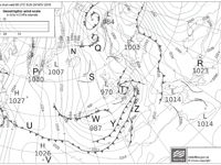
Refer to figure.
Over point N, at 2 000 ft, the wind is 000°/60 kt. The corresponding surface wind at point N is:
SURFACE WIND OVER LAND AND OVER SEA:
OVER LAND
- In the Northern Hemisphere, the surface wind backs by 30º compared to the geostrophic wind and speed is reduced by 50%.
- In the Southern Hemisphere, the surface wind veers by 30º from the 2000ft wind and speed is reduced by 50% compared to the geostrophic wind.
OVER SEA – friction is much less, and the surface winds are closer to geostrophic values.
- In the Northern Hemisphere, the surface wind backs by 10º from the geostrophic wind and speed reduces to 70%.
- In the Southern Hemisphere, the surface wind veers by 10º and speed reduces to 70% when compared to geostrophic winds.
⇒ In this case, point N is situated in the Northern Hemisphere over the sea. Consequently, the wind backs by 10º to 350º and amounts to 70% of the geostrophic wind, equaling 42 kt (60 x 0.7).
| Day | Night | |||
| Directional change | Percentage of "2000 ft wind" | Directional change | Percentage of "2000 ft wind" | |
| Land | 30° | 50% | 40° | 30% |
| Sea | 10° | 70% | 10° | 70% |
Your Notes (not visible to others)
This question has appeared on the real examination, you can find the related countries below.
-
Austro Control90
-
Germany35
-
Greece19
-
Poland19
-
Spain19
-
Ireland16
-
France12
-
Latvia11
-
Sweden10
-
Italy8
-
Romania8
-
Denmark6
-
Luxembourg4
-
Portugal4
-
Malta3
-
Switzerland3
-
United Kingdom3
-
Cyprus2
-
Czech Republic2
-
Norway2
-
Bulgaria1
-
Finland1
-
Hungary1
-
Lithuania1
-
Netherlands1
-
Serbia1
-
Slovenia1


Use your keyboard for faster navigation
